 12 Jan 2017
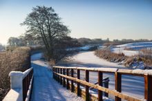
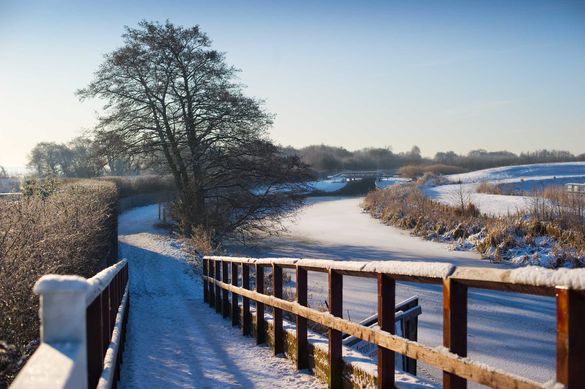
Banish the winter blues, embrace the fresh air and explore 17 new walking routes on the nation's tranquil waterways this winter.
The Canal & River Trust, working with the Royal Geographical Society and iFootpath, has created a host of easy to access walks that reveal the hidden history, architecture, wildlife and colourful narrowboats of our canals and rivers amidst relaxing views of the water.
Whether you want a short stomp with toddlers, a vigorous all-day hike with friends or a Sunday stroll to a cosy waterside pub, there are over 2,000 miles of traffic-free towpaths to explore in England and Wales.
Towpaths offer accessible and mostly level walking routes with little chance of getting lost as you follow the line of the meandering river or canal. Historic lock flights, charming hump-backed bridges and glimpses of the past - such as rope marks and mile posts - all add interest and no winter walk would be complete without coming across the welcoming lights of a friendly pub, café or teashop.
To find out more about the new walks or to discover interesting places near you visit: www.canalrivertrust.org.uk/walking.
Notes to Editors: 17 Walk Locations
Stourbridge walk: Known as the 'Crystal Canal' follow the Town Arm of the Stourbridge Canal to uncover why this area was ideal for glassmaking during the Industrial Revolution. Visit Britain's most complete working 'glass cone' and see Stourbridge's flight of 16 locks.
Start point: Canal Street, Stourbridge, West Midlands DY8 4LU
Finish point: Red House Glass Cone, Wordsley, West Midlands DY8 4AZ
Distance: one and a half miles
Dudley walk: Crossing four limestone hills, this walk not only offers geological insights into the area, but also delightful views of the West Midlands countryside.
Start point: Dudley Priory, Priory Park, Dudley, West Midlands DY1 4AY
End point: Wolverhampton Road, Sedgley, West Midlands DY3 1QR
Distance: five miles
Birmingham walk: Walking from the Bullring Shopping Centre to the bustling city centre – this walk explores Birmingham as the 'workshop of the world'. The city has been subject to constant change – discover how Birmingham's heritage is celebrated in cleverly-converted buildings and spectacular new ones.
Start point: The Bullring Shopping Centre, Birmingham B5 4BU
End point: Victoria Square, Birmingham B2 5TB
Distance: under two miles
Oxford walk: Built on a series of islands, discover the mill streams and flood meadows of Oxford, follow its once industrial canal and working river, watch leisure boating and follow the route of its historic annual boat race.
Start point: Oxford Castle, Oxford, Oxfordshire OX1 1AY
End point: Sandford Lock, Oxford, Oxfordshire OX4 4YD
Distance: five miles
Tring Reservoirs walk: Built through a gap in the Chilterns near Tring – the Grand Union Canal changed this area forever with four reservoirs, specially designed locks and today providing a great haven to watch wintering wildfowl.
Start point: Startop's End Reservoir car park, Marsworth, Buckinghamshire HP23 4LJ
End point: Startop's End Reservoir car park, Marsworth, Buckinghamshire HP23 4LJ
Distance: under six miles
Lancaster walk: Lancaster's vibrant waterways helped to shape the city. Called the 'Black and White Canal' because it used to carry coal and limestone - the canal was only recently connected to the national waterway network via the Ribble Link in 2002.
Start point: The Three Mariners pub, Bridge Lane, Lancaster, Lancashire LA1 1EE
End point: Westfield War Memorial, Village Gates West Road, Lancaster, Lancashire LA1 5PE
Distance: three miles
Saddleworth Walk: Windswept and interesting! Discover dramatic views, the country's longest tunnel, welcoming inns and beautiful countryside. The Huddersfield Narrow Canal scales the Pennines and its summit is the highest stretch of canal in Britain.
Start point: King Street, Delph, Oldham, Greater Manchester OL3 5DH
End point: Brownhill Countryside Centre, Wool Road, Dobcross, Greater Manchester OL3 5PB
Distance: six miles
Windmill End walk: Enjoy the scenic pathways of Windmill End, known as the Bumble Hole, which today are peaceful and relaxing but were once alive with the sounds of industry. This short walk follows the Dudley No. 2 Canal and Boshboil Arm to where it meets the Netherton Tunnel and finishes at Cobb's Engine House.
Start point: Bumble Hole Visitor Centre, Dudley, West Midlands DY2 9HU
End point: Cobb's Engine House, Rowley Regis, Dudley, West Midlands, DY2 9HU
Distance: one mile
Aldermaston Wharf and Padworth walk: Starting from the visitor centre on the Kennet & Avon canal this walk encompasses the once very busy Aldermaston Wharf. In its heyday goods of coal, timber, grain, beer, gravel, brooms and baskets were loaded here.
Start point: Aldermaston Wharf Visitor Centre, West Berkshire RG7 4JS
End point: Aldermaston Wharf Visitor Centre, West Berkshire RG7 4JS
Distance: three miles
Reading walk: Encompassing the Thames and Kennet this circular walk takes in industrial areas and the historic grounds and ruins of Reading Abbey.
Start point: Queen Victoria statue in Blagrave Street, Reading, Berkshire RG1 1QH
End point: Queen Victoria statue in Blagrave Street, Reading, Berkshire RG1 1QH
Distance: three miles
Woolhampton walk: Begin and end at the Rowbarge pub – offering great views of the canal and its swing bridge. This walk follows the Kennet & Avon Canal towpath along to Aldermaston Wharf and on to the River Kennet alongside its reedbeds before following quiet lanes and grazing pastures.
Start point: Rowbarge pub, Station Road, Woolhampton, West Berkshire RG7 5SH
End point: Rowbarge pub, Station Road, Woolhampton, West Berkshire RG7 5SH
Distance: six miles
Batchworth Lake walk: Walk from Rickmansworth's Aquadrome, set within a Local Nature Reserve, and enjoy a real mix of bustling towpaths with locks and colourful narrow boats to peaceful rivers with plenty of wildlife.
Start point: Rickmansworth Aquadrome, Frogmoor Lane, Harefield Road,Hertfordshire WD3 1NB
End point: Rickmansworth Aquadrome, Frogmoor Lane, Harefield Road, Hertfordshire WD3 1NB
Distance: four miles
Cannock Chase walk: Designated as an Area of Outstanding Natural Beauty, Cannock Chase has extensive woodland and parkland to explore. The walk is set within the floodplain of the River Trent and follows the Trent & Mersey Canal.
Start point: Seven Springs car park, near Wolseley Bridge and Milford, Staffordshire, ST17 0XS
End point: Seven Springs car park, near Wolseley Bridge and Milford, Staffordshire, ST17 0XS
Distance: five miles
Thrupp walk: The picturesque Oxford Canal meanders slowly through largely undeveloped countryside – dotted with simple black and white lift bridges and with mostly pretty villages along its length. This walk follows the canal and River Cherwell through woods, pastureland to return to the pretty village of Thrupp - served by both tea room and pub.
Start point: Annie's Tea Room, Thrupp, Kidlington, Oxfordshire OX5 1JZ
End point: Annie's Tea Room, Thrupp, Kidlington, Oxfordshire OX5 1JZ
Distance: three miles
Long Itchington walk: Stroll alongside the idyllic Grand Union Canal, discover the village of Long Itchington, named after the River Itchen and follow woodland paths, arable farmland and towpaths before returning for refreshment in the public houses of 'Long Itch'.
Start point: Holy Trinity Church, Long Itchington, Warwickshire CV47 9PN
End point: Holy Trinity Church, Long Itchington, Warwickshire CV47 9PN
Distance: eight miles
Fradley Junction Walk: This walk explores farmland, villages as well as sections along the Trent & Mersey Canal. At Fradley Junction there are listed cottages, a warehouse, a crossover bridge and lock, original stables, carpenter's shop and Blacksmiths (which now form part of the café and visitor centre) as well as a nature reserve and family trail.
Start point: Fradley Junction car park, near Alrewas, Kings Bromley, Staffordshire, DE13 7DN
End point: Fradley Junction car park, near Alrewas, Kings Bromley, Staffordshire, DE13 7DN
Distance: seven miles
Whitchurch Walk: Starting and finishing from the Cock and Greyhound public house this walking route travels through farmland and a golf course before returning alongside the Shropshire Union Canal. It has some interesting canal features and wildlife to spot including otters and watervoles.
Start point: Cock and Greyhound pub, Bargates, Whitchurch, Shropshire SY13 1LL
End point: Cock and Greyhound pub, Bargates, Whitchurch, Shropshire SY13 1LL
Distance: five miles
-ends-
For further media information, 'What to spot whilst you're by the water' and images:
Liz Woznicki, Canal & River Trust: 07796 191120 Liz.Woznicki@canalrivertrust.org.uk